GPS observations of Sierra Negra
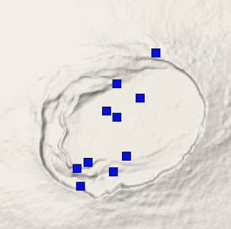
The largest and most active volcano in the Galapagos island is Sierra Negra, which had its last eruption in 2005. The University of Idaho and Oregon State University in coordination with IG Quito operate a continuous GPS network in and near the summit caldera to record ground inflation due to the influx of new magma into magma chamber. The chamber is located at ~2 km depth beneath the caldera floor. Click on the image above to access the near-real time displacement time-series processed by the University of Nevada in Reno. The vertical displacement time-series (lower plot) of station GV04 is the easiest to interpret.
There is an increased eruption probability during periods of rapid caldera floor inflation. There is another increase in the eruption probability if earthquakes occur simultaneously with rapid caldera floor inflation.
Magma supply to the Galapagos volcanoes
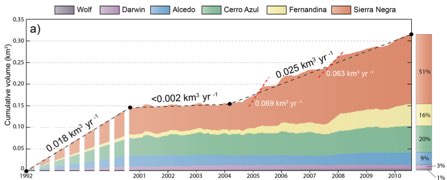
The Galapagos volcanoes are known to be very active with an average of 3 eruptions every 10 years, but it was not known, how much magma exactly is supplied to shallow levels. Marco Bagnardi used the InSAR-derived ground deformation history over the past 20 years and models of magma accumulation for each volcano to infer the magma supply rate. He found that the magma volume under the volcanoes increased at a rate of about 0.018 km3/yr averaged over two decades. About half of the supplied magma headed towards Sierra Negra, the largest of the volcanoes. This magma supply rate is about 1/5 of the Hawaiian volcanoes. Please e-mail marco for a copy of our submitted paper.
Magma propagation by radial or circumferential dikes?
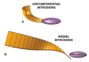
How does magma propagate to the eruption site at a basaltic volcano? From volcanoes in Hawaii, Iceland and Afar we know that the dominant mode for magma propagation is by sub-vertical dikes. Marco Bagnardi used a SAR image, acquired 2 hours prior to the 2009 eruption of Fernandina volcano in the Galapagos Islands, to show that the erupted dike initiated as a sill. Magma-propagation in form of sub-horizontal sills could explain many morphological differences between the Hawaiian and Galapagos volcanoes. See our EPSL paper.
Fernandina’s double-decker magma system
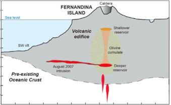
Geodetic observations at active volcanoes are generally explained using a single inflation source, which for most of the Galapagos volcanoes is a sill-type reservoir at 1-2 km beneath the caldera floor. Marco Bagnardi examined InSAR data of Fernandina volcano in detail and found evidence for two inflation sources, one beneath the caldera and the other one at 5-6 km depth, either within the lower crust or at the Moho. The shallow intra-caldera reservoir feeds eruptive fissures, whereas the deeper one feeds subvolcanic intrusions. See Marco’s JGR paper.
Tsunami risk in Villamil, Isabela, Galapagos
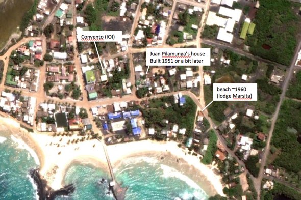
To better understand the hazards of transoceanic tsunamis in the Galapagos islands, we are trying to understand how the tsunami associated with the 22 May 1960 Chile earthquake (M9.5) affected the populations. On March 29, 2014, Falk Amelung and Marc Martorell (IOI), interviewed two seniors who were living in Villamil when the earthquake occurred. The interviews indicate that the tsunami had only minor effects. According to one witness it resulted in little higher water levels than usual (“the cargo on the beach got wet”). Another witness who lived close to the beach (50-100 m at the time) only recalls turbulence in the water but does not talk about any flooding of his house.


